Partial adjustment of the detailed planning of the control of the neighbourhood control of 02PD-0001, Unit 1, 2, 3 and 4, Chuansha New Town, Pudong New District, Shanghai
Draft announcement
In order to make the public fully understand the content of the draft plan and widely solicit public opinions, the draft of the "Partial Adjustment of the Controlled Detailed Planning of the Neighbourhood Control of Unit 1, 2, 3 and 4, 02PD-0001, Chuansha New Town, Pudong New District, Shanghai" is hereby announced as follows;
- Public notice date: January 24, 2025 - February 23, 2025 2. Public announcement method: online public announcement for details, please refer to the website (https://www.pudong.gov.cn/shir/)
The on-site public address is No. 700, Shendi North Road, Pudong New District, Shanghai.
- Public feedback method: In order to facilitate the collection and statistics of opinions, in the form of written mail, fax and e-mail shall prevail.
Mail feedback: Please mail your written comments to No. 700 Shendi North Road, Pudong New District, Shanghai (postal code: 201205, fax number: 20991030) or send an email to the mailbox (chengy@pudong.gov.cn), and indicate the recipient "Shanghai Pu
Collection of opinions on the partial adjustment of the controlled detailed planning of the neighbourhood in Unit 1, 2, 3 and 4, Chuansha New Town, 02PD-0001, Chuansha New Town, Dongxin District.
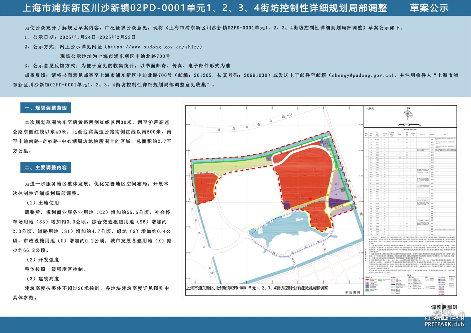
I. Scope of planning adjustment The scope of this plan is 30 metres west of the red line on the west side of Tanghuang Road in the east, 40 metres east of the red line on the east side of the Shanghai-Lu Expressway in the west, 500 metres south of the red line on the south side of the Yingbin Expressway in the north, and the area surrounded by the plots around Shendi South Road-Wonderful Road-Central Lake in the south, with a total area of about 2 .7 square metres
Square kilometres.
II. Main adjustment content
In order to further serve the overall development of the region, optimise and improve the spatial layout of the region, and carry out this
Sub-controlling detailed planning and partial adjustment.
(1) After the adjustment of land use, the planned commercial service land (C2) will increase by about 55.5 hectares, and the social shutdown
The parking lot land (S3) increased by about 3.3 hectares, the comprehensive transportation hub land (S6) increased by about 2.3 hectares, the road land (S1) increased by about 4.7 hectares, the green space (G) increased by about 0.4 hectares, the municipal facilities land (U) increased by about 0.2 hectares, and the urban development reserve land (X) Subtract
Less than about 66.2 hectares.
(2) Development intensity
The whole is controlled according to the first-level intensity zone.
(3) Building height
The height of the building is controlled according to the overall height of no more than 20 metres. For details of the building height of each block, please refer to the figure.
Specific parameters.